Recommended Articles
The Golden Girls of Barrhaven: Making the Move
Baa, Baa, Black Sheep
Ottawa airline bail-out still in consideration

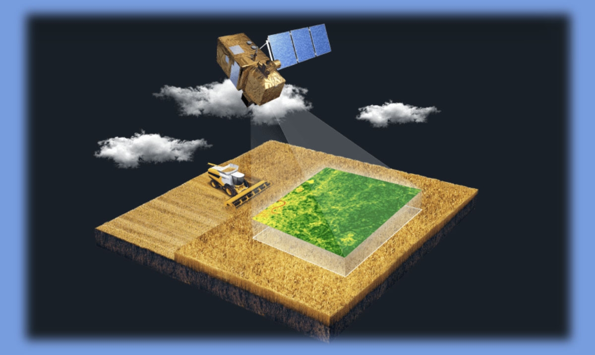
Satellite imagery is used in many areas of human activity. This technology has found its application in geology, education, environmental protection, forestry, as well as in agriculture, and many other activities. Although satellite imagery has been used for many years, the technology continues to evolve and improve. In this piece, you can find out how agriculture satellite imagery works and how it is used in forestry.
Agriculture and forestry require solutions for near real-time monitoring to cope with current and future challenges. It's connected to environmental issues, growing population, and increasing demand for agricultural products. According to estimates, by 2050, about 9 billion people will live on our planet.
For agriculture, this means a 70% increase in production. Food security is still facing difficulties due to climate change. Agriculture can help solve both of these problems. Therefore, FAO emphasizes the need to invest in various sectors of agriculture.
Forests also play a critical role in the fight against climate change. More than 36 billion tons of carbon dioxide are emitted into the atmosphere every year. Conserving and restoring forests can help reduce emissions by up to 7 billion tonnes per year.
Agriculture and forestry need investment and protection to meet the challenges of climate change and a growing population. Monitoring is critical in addressing the challenges of these industries. It is crucial because near real-time monitoring can respond in time to threats, including fires or pest outbreaks.
Thanks to remote sensing, satellites can provide us with much more data than we can get from the ground. Satellite images make it possible always to be aware of what is happening in forests or agricultural land. It is an indispensable tool for monitoring and managing extensive forests and farming lands. Satellite imagery data gives us insight into crop and land cover health, biodiversity, soil degradation, and livestock health.
The technology for obtaining data from satellite images has become more affordable. Many companies offer services through which the user receives the final information products. You don't need any additional hardware to get the data. AI and machine learning technologies make it possible to use a large dataset that was not previously available.
With this data, for example, you can see areas prone to flooding. It provides enhanced capabilities for monitoring and preventing potentially dangerous situations. It is also important to note that many types of data are provided to users free of charge, and additional products are available for an additional fee. So free images are used in many fields of activity and by various applications.
One of the main advantages of satellite imagery is seeing what is happening in places where you cannot get there. This is important, for example, for observing cyclones in remote areas on our planet. For this reason, decision-makers and Earth observers must interact. Streaming services make satellite data more accessible. In addition, this data becomes free for various organizations and companies, and they can offer additional services to their users.
The GPS collects data in real-time. With this data, farmers can determine the effectiveness of agricultural methods and optimize the farm's production systems. This technology also helps define the farm's boundaries accurately and solve problems that arise during the plowing of fields.
The GPS of the farm is connected to the GPS of satellites and agricultural machinery, and they swap data. Due to this system, farmers receive field maps with marked boundaries and reliefs. GPS is also helpful at plowing the land, as it can be used to more accurately create furrows and then place seeds in them.
The use of GPS technology also helps to improve field productivity and save money. Thanks to this system, you can determine in which areas there are insufficient nutrients. Farmers do not need to distribute fertilizers throughout the field evenly. They can apply a certain amount of fertilizer to a particular site. It should lead to increased efficiency.
The GPS also allows you to monitor the yield. You can define variable yields on different parts of the farm. In this way, you can make it easier to determine the correlation between the farming methods used and productivity. To identify patterns, farmers can compare yield maps with a map that shows a variable rate of fertilization.
Forests are an essential part of life on Earth, not only as a valuable resource, but also because they play a critical role in absorbing carbon dioxide. Forests have been challenging to observe in the past as they exist on a large scale. However, everything is changing thanks to the development of space technologies and the availability of satellite data.
The European Space Agency is preparing to launch the Biomass satellite in 2021. Thanks to the synthetic aperture radar, it will penetrate the forest canopy and collect data on the density of the forest. The satellite will help determine how much land is covered by the forest and how much wood exists in it. Over the next five years, the satellite will provide scientists with forest density data over eight growth cycles.
Projects are also being developed to track illegal logging, forest fires, and various changes taking place in forests. Through such projects, governments and scientists will assess the rate and extent of deforestation in different countries, determine the causes and find ways to repair the damage and encourage beneficial forestry practices.
The forestry industry faces a range of economic challenges. In addition, the sector is severely affected by natural disasters. The major timber-producing countries face forest fires, pests, and tree diseases every year. In this case, large areas are involved, so rescue operations are expensive.
All these difficulties lead to the fact that it is necessary to look for and implement new forest management and monitoring methods. Sustainable forest management is also a necessity for maintaining biodiversity and ecosystem health. This concept also implies maintaining the cleanliness of the soil, fighting diseases, and pests.